To state the obvious: It must be something wrong in the Emlid VTG data. Either the output or the readings. Or in the RS5 VTG reading. Is it possible to connect another gps (another brand) to the rs5 to see if you have the same issue? If so, the issue is how the RS5 reads/interprets the VTG data. Another suggestion: If it is possible to connect the Emlid to a PC/PDA/phone and read VTG data, try walking north at 1 m/s and check if VTG data agrees. (Or: Return GPS and rs5 to manufacturer/dealer and tell them that something is wrong)
I’m in touch with Sontek about some other issues, I’ll add this to the pile..
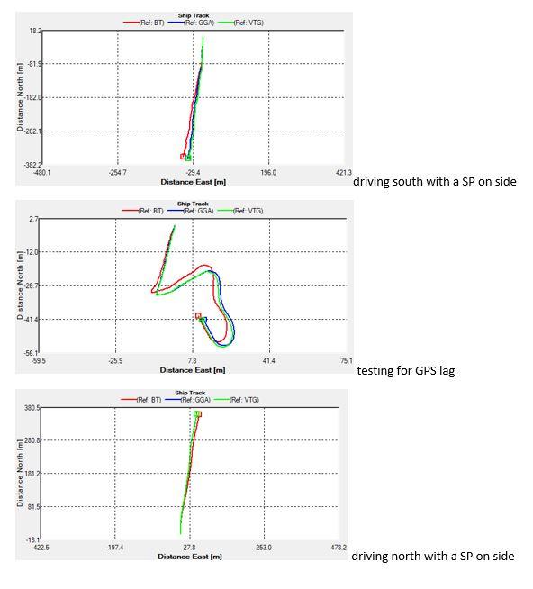
Dave: Thank you for confirming my hypothesis, I will try to do a fast transect and see whether it starts to align better. I must say with the RS5s slight issues with bottom tracking, GPS has been very useful. What is a bit concerning is that of course the discharge with a bit of lost bottom track tend to be biased slightly low.
Another question, which may deserve it’s own topic is that the RS5 reports altitude based on a “non-published, proprietary geoid” instead of pulling height above the ellipsoid from the GGA string. The geoid seems to be quite close to MSL, but since it is “secret” altitude mapping with the RS5 is, at least from my limited geodetic abilities, impossible?
I know the raw gps data is exported into the Qrev matlab files. Can we also pull altitude above ellipsoid from Qrev Dave?
/Daniel
 .
.